Globes and geography resources for primary schools: a buying guide
Quick Answer
Primary schools require a structured progression of geography resources—globes, maps, atlases, and fieldwork tools—to align with the National Curriculum. Combining physical engagement with visible, daily access transforms classroom curiosity into meaningful locational knowledge and investigative skills across all Key Stages.
In this article
- What geography resources does a primary school need?
- Why do globes remain important in primary geography?
- Which globe is best for a primary classroom?
- What maps and atlases should primary schools use?
- How can schools encourage geographical curiosity?
- How many globes does a primary school need?
- Why does geography resource quality matter?
- How do GLS support geography teaching?
- Frequently Asked Questions
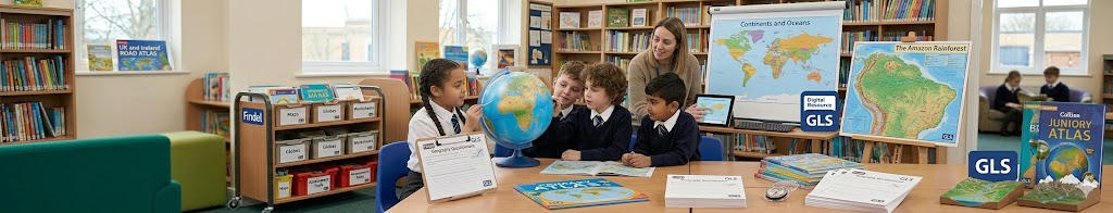
Maps, atlases and globes are essential geography resources in primary schools. They help pupils develop locational knowledge, understand physical and human geography, and build the enquiry skills required by the National Curriculum. However, the most effective geography resources do more than support curriculum coverage — they help children develop curiosity about the wider world and understand how places, people and environments are connected.
For many children, geography begins with a simple question:
- "Where is that?"
- Where is the country we've been reading about?
- Where does this river start?
- Why is it daytime here but night-time somewhere else?
These questions sit at the heart of great geography teaching. The challenge for schools is helping pupils move beyond simply identifying places on a map towards understanding how the world works. This is where geography resources become so important. A globe can help a Year 2 pupil understand that the Earth is round rather than flat. An atlas can help a Year 5 class compare climates across continents. A fieldwork activity can help pupils connect what they learn in the classroom with the world outside the school gates.
At Findel, we believe the best educational resources help transform curiosity into understanding. Geography is one of the few subjects that allows children to explore both their local community and the wider world, making it a powerful driver of curiosity, enquiry and lifelong learning.
What geography resources does a primary school need?
Most primary schools build their geography provision around four core resource types:
- Globes: Help pupils understand the Earth as a three-dimensional object.
- Maps: Develop spatial awareness, directional understanding, and locational knowledge.
- Atlases: Support independent enquiry as pupils move through Key Stage 2.
- Fieldwork resources: Help pupils connect learning to real places using tools like local maps and surveys.
Each serves a different purpose within the curriculum. GLS works with schools across the UK to support curriculum delivery, and geography leaders consistently tell us that pupils learn best when they can interact with resources rather than simply observe them. Geography is inherently visual and investigative, making high-quality resources particularly important.
Globes
Globes help pupils understand the Earth as a three-dimensional object. They support learning around:
- Continents
- Oceans
- Hemispheres
- Latitude and longitude
- Global relationships
Many geographical concepts become easier to understand when pupils can physically explore them rather than viewing them on a flat page.
Maps
Maps develop spatial awareness, directional understanding, locational knowledge, and knowledge of both physical features and human settlements. Large classroom maps can become everyday learning tools rather than resources used only during geography lessons.
Atlases
Atlases support independent enquiry. As pupils move through Key Stage 2, atlases become increasingly valuable because they encourage children to investigate questions for themselves rather than relying solely on teacher explanations.
Fieldwork Resources
Fieldwork helps pupils connect learning to real places. Resources such as local area maps, aerial photography, observation sheets, and survey tools allow children to apply geographical knowledge in meaningful contexts. The strongest geography provision combines all four resource types to create a richer learning experience.
Why do globes remain important in primary geography?
Despite the growth of digital mapping tools, globes remain one of the most valuable geography resources available to schools. GLS regularly supports schools developing enquiry-led geography provision, and one challenge frequently raised by teachers is helping pupils visualise concepts that cannot easily be demonstrated on a flat map.
For example, globes make these key structural questions much easier to understand:
- Why do time zones exist?
- Why do seasons vary around the world?
- Why are flight paths curved?
- How are continents positioned relative to one another?
Children naturally pick up a globe, spin it and ask questions. Those moments of curiosity often become some of the most powerful learning opportunities in the classroom.
Which globe is best for a primary classroom?
Different globe types support different learning experiences throughout the early year phases:
- Inflatable Globes: Best for EYFS, KS1, and group activities. Younger children enjoy physically interacting with inflatable globes, making them highly effective for introducing geographical concepts.
- Desktop Globes: Best for KS2 classrooms, teacher demonstrations, and independent pupil exploration. For many schools, desktop globes provide the greatest educational value because they are used regularly and remain visible throughout the year.
- Illuminated Globes: Best for geography and science links alongside cross-curricular learning. These can support teaching around day and night, seasons, and the Earth's relationship with the Sun.
- Large Demonstration Globes: Best for libraries, shared curriculum areas, and dedicated geography hubs.
Interestingly, GLS often finds that the most-used geography resources are not necessarily the most expensive. Smaller classroom globes frequently generate more discussion and enquiry because pupils can interact with them directly rather than viewing them from a distance.
What maps and atlases should primary schools use?
The complexity of geography resources should increase as pupils move through the school to align with cognitive development.
EYFS and KS1
Useful resources include picture maps, simple world maps, UK maps, and inflatable globes. At this stage, the focus remains primarily on awareness, recognition, and fundamental vocabulary development.
Lower KS2
Useful resources include junior atlases, physical maps, political maps, and desktop globes. At this phase, pupils begin exploring broader geographical relationships and developing deeper enquiry skills.
Upper KS2
Useful resources include detailed atlases, climate maps, biome maps, OS-style maps, and aerial photography. These resources support more sophisticated geographical investigations and independent research initiatives.
GLS curriculum specialists often highlight the importance of progression when reviewing geography provision. Resources should become increasingly detailed and challenging as pupils advance through the school, helping children build confidence as young geographers.
How can schools encourage geographical curiosity?
One pattern GLS regularly observes when supporting schools is that geography resources often become less effective when they are stored away in closed environments:
- Atlases in cupboards.
- Globes on top shelves.
- Maps only displayed during a specific topic window.
The schools achieving the strongest geography outcomes often take a different approach. They make resources highly visible. A globe becomes part of everyday classroom conversation, an atlas is available whenever a pupil asks a question, and maps are used across multiple subjects rather than only during designated geography lessons.
This integrated approach helps children see geography as something that explains the world around them rather than simply another isolated curriculum subject. It also supports one of the most important aims of geography education: developing lifelong curiosity.
How many globes does a primary school need?
There is no universal answer. However, accessibility is often more important than pure quantitative capacity. For many schools, a sensible starting point might include:
- Classroom globes across each educational phase
- Shared specialist curriculum resources
- Dedicated atlas sets for Key Stage 2
- Large wall maps for communal areas and corridors
When reviewing geography resources, GLS often encourages schools to think about frequency of use rather than simply product numbers. A globe that is used every day will typically deliver more systemic educational value than several high-end globes stored away for occasional lessons.
Why does geography resource quality matter?
Children develop geographical understanding through repeated exposure to accurate, engaging, and accessible information. High-quality resources actively help pupils:
- Build secure locational knowledge
- Identify intricate global patterns
- Explore environments independently
- Develop robust geographical vocabulary
- Understand complex global relationships
For teachers, quality tools support stronger, fluid curriculum delivery. For geography leaders, they help create vital consistency across year groups. For pupils, they make the world feel larger, more connected, and infinitely more interesting. This reflects a wider belief across the Findel family: educational resources should support meaningful outcomes, not simply fulfil purchasing requirements. The right resources help children develop confidence, understanding, and curiosity that extends far beyond a single lesson.
How do GLS support geography teaching?
Great geography teaching requires more than a collection of maps and atlases. It requires resources that support progression, encourage enquiry, and help pupils engage with the wider world. GLS helps schools source the practical classroom resources needed to deliver geography consistently across the whole school.
Whether supporting a single classroom, a geography lead reviewing provision, or a School Business Manager planning curriculum investment, GLS works with schools to ensure resources remain accessible, affordable, and effective. Together, as part of the wider Findel family, Hope Education and GLS help schools move beyond simply teaching geography and towards creating confident, curious learners who want to understand the world around them.
Frequently Asked Questions
Are globes required for primary geography?
The National Curriculum does not require specific products, but it does reference globes alongside maps, atlases and digital mapping as important geography tools.
What is the best globe for a primary classroom?
For most schools, a desktop globe offers the best balance of visibility, durability and educational value. Inflatable globes are particularly effective in EYFS and KS1.
Do pupils still need atlases if schools use digital maps?
Yes. Atlases help develop independent research skills and support geographical enquiry alongside digital mapping technologies.
Which geography resources should schools prioritise?
Most schools prioritise globes, maps, atlases and fieldwork resources because they align closely with National Curriculum requirements and support progression across the primary years.
How often should atlases be replaced?
Atlas sets should be reviewed periodically to ensure information remains accurate and up to date. High-use classroom sets may require more frequent replacement.
How do geography resources support fieldwork?
Maps, aerial photographs and observation tools help pupils investigate real environments and apply geographical skills in meaningful contexts.
Why is geographical curiosity important?
Curiosity encourages pupils to ask questions, investigate ideas and develop a deeper understanding of the world. These habits support learning across geography and beyond.
Author
David Reynolds
Humanities & Geography Education Advisor